
A group of us met on this fine Saturday morning to clear the area around another grave, that of Albert Best, which is to be found just behind the surviving chapel in the Old Cemetery. I will post up a separate story about Albert Best since he was quite a leading light in Teignmouth during his time and has left us a legacy of contemporary social history through his diaries.
However, there was another reason for getting together. Thanks to Tacy Rickard I had been pointed to an electronic copy of a lithograph print of the Cemetery, dated 1864. I thought it would be interesting to try to take a modern photograph to compare with the original picture.

(The lithograph has been reproduced with kind permission of the Devon Archives and Local Studies Service based at the Devon Heritage Centre in Exeter)
Starting with the original lithograph, the view appears to have been taken from the direction of the Higher Buckeridge Road end of the cemetery uphill from the current main entrance. So enter through the main entrance, turn right and take the first main path to the left.
The path in the lithograph appears to be wide and cobbled, which is supported by the discovery of cobblestones close to the first grave that was cleared (Leah Laforgue). The present day path is narrower and grassed but there seems to be a tarmac layer underneath. So we could speculate that tarmac at some time was laid over the cobbles and then couch grass has over time taken over the tarmac.
There seems to be a little artistic licence in the picture. For example: the chapel roof angles differ from the actual roof (unless there has been reconstruction); and the view is as though you are looking down onto the cross (X) in the picture and up towards the chapel. It is difficult to see where this viewpoint could have been.
There are four reference points marked on the lithograph, only two of which are visible today. ‘A’ I think is St. Michael’s Church; ‘B’ seems to be the slightly hillier area next to Rocky Lane along Exeter Road; ‘C’ is the chapel itself; and ‘X’ is the cross which is the closest fix-point for the picture.
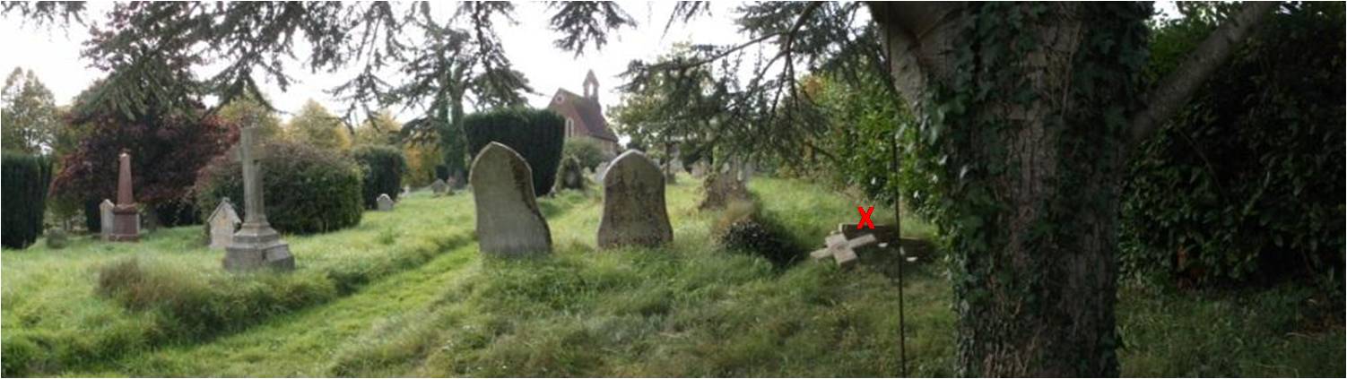
Comparing the lithograph with the present-day photograph you can see that:
- The reference points ‘A’ and ‘B’ are no longer visible, blocked by trees;
- The chapel ‘C’ is slightly different in shape;
- The cross ‘X’ is now broken and its position suggests that the original viewpoint was further to the right of the position from where the photo was taken. However, as can be seen in the photo, there is now a tree obscuring the view at the front and also there is a dense hedge to the right of the cross which prevents taking a stand further to the right.
The broken cross is dated 1862 so fits well with the date of the lithograph; and the shape of both the plinth and the cross itself match the lithograph picture. This grave is of a child age 8, Wilhelm Carl Edward Bodnar, who may be at the heart of an interesting story – the research is ongoing.

Interesting engraving – it shows the now ruined building to the west of the chapel
LikeLike